|
Application of cyber city technologies for real estate, tourism, environmental studies, transport, and logistics. Satellite remote sensing of the urban heat island, green space, and modeling of urban environmental quality though data integration
Nichol, J.E. and Lee, C.M, (2005). Urban vegetation monitoring in Hong Kong using high resolution multispectral images. International Journal of Remote Sensing, 26(5), 903-918, U.K. Dai, E.F., Shi, W.Z., Wu, S.H., Cheung, C.K. and Shaker, A. (2005). Monitoring and assessment of land use change: a remote sensing, GIS and neural networks integrated approach. Journal of Environmental Management (Accepted) Nichol, J.E. Wong, M.S., Lam, A., Fung, C. and Leung, K. (2005) forthcoming. Assessment of urban environmental quality in a sub-tropical city using multispectral satellite images, Environment and Planning B. Nichol, J.E and Wong, M.S. (2005). Modelling urban environmental quality in a tropical city. Landscape and Urban Planning, 73, 49-58. Nichol, J.E. (2005) Remote sensing of urban heat islands by day and night, Photogrammetric Engineering and Remote Sensing, 71(5) 613-621. Li, H., Kong, C.W., Pang, Y.C., Shi, W.Z. and Yu, Ling (2003). Internet-based Geographical Information Systems for e-Commerce Application in Construction Material Procurement, ASCE Journal of Construction Engineering and Management, 129(6):689-697 (EI).
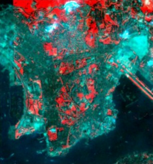
Selected projects on application of Cyber-City technologyA Framework for Developing a Unified B2B e-Trading Construction Marketplace John SHI, LI Heng and CAO Jian-nong E-commerce systems are becoming increasingly important in the Hong Kong construction material procurement market. Currently, many e-trading marketplaces have been developed, owned, and/or hosted by different companies. Each of the e-trading marketplace forms a closed system with their own customers and clients. The totality of these e-trading marketplaces appears to be islands in the sea, as they are isolated and with no interoperation between each other. In this research project, we aim to develop an interoperable e-trading marketplace for the construction industry by linking all the existing e-trading marketplaces, as any single e-trading market place may not be able to meet all the requirements of the buyers. We propose the concept of the e-Union, which can integrate the services provided by different e-trading marketplaces in the construction industry to provide an open and unified e-trading marketplace, or e-Union, which is enabled by the use of a mobile agent. Development of a structural health monitoring and management system based on GIS J.M. KO, John SHI, Tommy CHAN, Y.Q. NI, Lilian PUN and LI Zhi-lin This project develops a structural health monitoring and management system based on GIS, and has the following objectives: ? development of a GIS-based health monitoring information system, ? development and integration of structural health monitoring and analysis models, and ? a study of the feasibility of developing an internet GIS for distributing health monitoring and management information. Monitoring of urban green space using high resolution satellite images Janet Nichol and Lee Chun Man Very high resolution (VHR) satellite remote sensing systems are now capable of providing imagery with similar spatial detail to aerial photography, and they are superior spectrally. This research investigates the theory that it should be possible to use multispectral IKONOS images to quantify urban vegetation, obtaining similar accuracy to that achieved from false colour aerial photographs. The green/red ratio (Figure 38) was found to be the best vegetation index. Its superiority to the NDVI is attributed to the sub-optimal timing of the imagery during the dry season, and its greater sensitivity to multiple layering within the vegetation canopy.
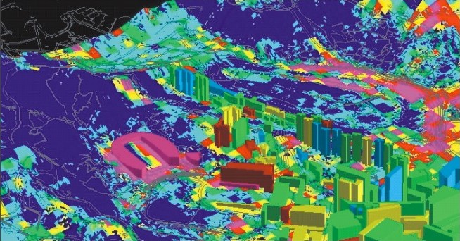
Figure 38. IKONOS VHR image of the Kowloon Peninsula, Hong Kong (green-red ratio) Modelling of urban environmental quality Janet NICHOL and WONG Man-sing Environmental quality is an abstract concept resulting from both human and natural factors operating at different spatial scales. In urban areas the local scale is dominated by individual buildings, streets and trees, but regional scale influences may include the whole city and beyond. Current satellite-based sensing systems are able to depict parameters of Urban Environmental Quality over large areas at detailed level, using 3-D Virtual Reality models. A method is developed for increasing the spatial detail and spectral accuracy of Landsat ETM+ thermal data, by fusion with an IKONOS image representing vegetation. Additionally, by depicting the complete radiating surface involved in energy exchange between the surface and atmosphere, including vertical walls, as well as the horizontal surfaces ‘seen’ by the satellite, a more accurate representation of the urban thermal environment is obtained. The models (Figure 39) permit 3-D visualization and fly-through animation to represent Urban Environmental Quality, based on quantifiable image parameters, and assist the understanding of the complex and dynamic factors controlling Urban Environmental Quality. Model showing the temperature difference between the National Stadium, having a cover of artificial turf, and the Hong Kong racecourse with real grass cover. The image is of sufficient resolution to depict the cooler shadowed area within the stadium due to the low sun angle on this early morning image. Temperatures from Landsat ETM+ thermal band.
Figure 39. Rendered 3D model of surface temperature extracted from Landsat thermal band showing the racecourse and national stadium, Hong Kong. |