|
GPS and radar remote sensing technologies are used to study the atmospheric conditions, especially the water vapour content in the troposphere, the total electron content in the ionosphere, and their variations in space and time. An additional recent focus is on the calibration of satellite-derived aerosol optical thickness (AOT) from NASA’s MODIS satellite, using sun-photometer measurements and data from air pollution monitoring stations. The research provides information for weather and air quality forecasting and for study of environmental changes.
Tse, M. and Iz, H.B. (2005). Deflection of the Vertical Components from GPS and Precise Leveling Measurements. Journal of Surveying Engineering, (in press). Li, Z.W., Ding, X.L. and Liu, G.X. (2004) Modeling Atmospheric Effects on InSAR with Meteorological and Continuous GPS Observations: Algorithms and Some Test Results, Journal of Atmospheric and Solar-Terrestrial Physics, 66:907-917. Zheng, D.W., Ding, X.L., Zhou, Y.H. and Chen, Y.Q. (2003). Earth rotation and ENSO events: combined excitation of international LOD variation by Multiscale atmospheric oscillations. Global and Planetary Change, 36: 89-97. Liu, Y.X. and Chen, Y.Q. (2002). Improving accuracy of near real-time precipitable water vapor estimation with the IGS predicted orbits. Geophysical Research Letters, 29(16):41.1-41.3. Zheng, D.W., Ding, X.L., Zhou, Y.H. and Chen, Y.Q. (2002). Earth Rotation and ENSO Event: Synthetic Excitation of Interannual LOD Variations by Multi-Scale Atmospheric Oscillations, Global and Planetary Change, 36:89-97. Dodson, A.H., Chen, Wu, Penna, N.T. and Baker, H.C. (2001). GPS estimation of atmospheric water vapour from a moving platform. Journal of Atmospheric and Solar-Terrestrial Physics, 63:1331-1341. Penna, N.T., Dodson, A.H. and Chen, Wu (2001). Assessment of EGNOS tropospheric correction model, Journal of Navigation, 54(1):37-55.
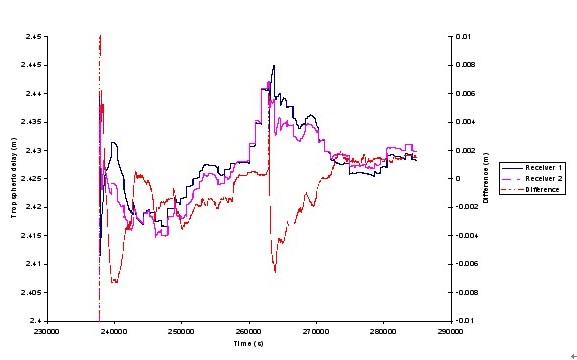
Selected projects on Atmospheric sensing Estimation of atmospheric water vapour using GPS CHEN Yong-qi and CHEN Wu Understanding water vapour content and its change in the atmosphere is important for meteorological and climatological research. In recent years, a technique of remote sensing water vapour in the atmosphere using GPS has been rapidly developed. The estimation accuracy of 1-2 kg/m2 has been routinely available from ground based GPS networks. Extending this technique into the sea on a moving platform would be greatly beneficial for the meteorological research, such as calibration of satellite data and investigation of sea/air interface. A new method based on Kalman filter technique has been developed to estimate water vapour under a kinematic environment. In order to assess the quality of the estimated tropospheric delay from a moving platform, the differences between the estimated tropospheric delays from the two receivers on the boat were analysed. Figure 8 shows the estimated tropospheric delays for the two receivers on the boat and the differences between the two estimates. It is clearly shown that the two estimates agree at about the 2 mm level, except during the initial period before the filter has stabilised. The experiment shows that the estimated tropospheric delay on a moving platform is compatible to that on land.
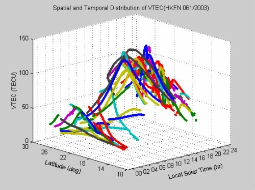
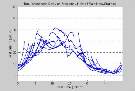
Figure 8. Comparison of two receivers on the boat Ionosphere Monitoring using GPS CHEN Wu, CHEN Yong-qi and DING Xiao-li Ionospheric delay is an important error source in GPS navigation. The ionospheric activities also affect communication and satellite operations. With dual frequency GPS observation, the ionospheric activities can be observed. In recent years, we have concentrated on the study of ionospheric disturbances in Hong Kong and their effects on GPS (Figure 9). Also, a new method is proposed to establish a precise local ionospheric delay model based GPS reference network (Figure 10).
Figure 9. 3D distribution of Ionsopheric delay in Hong Kong
Figure 10. Precise estimation of ionsopheric delay in Hong Kong |