|
This research area emphasises the synergistic use of GPS and tide gauge records to monitor historical and present changes in sea level in the Hong Kong and south China region, as well as the use of satellite radar altimetry for the detecting relative height changes in lake levels.
Iz, H.B. and NG, H.M. (2004) Are the Global Tide Gauge Data Stationary in Variance? Marine Geodesy (in press). Ding, X.L., Zheng, D.W. and Yang, S. (2002) Variations of the Surface Temperature in Hong Kong During the Last Century, International Journal of Climatology, 22:715-740. Ding, X.L., Zheng, D.W., Chao, J., Li, Z.L. and Chen, Y.Q. (2001) Sea level variations in HK from tide gauge measurements, Journal of Geodesy. 74: 683-689. Ding, X.L., Chao, J., Zheng, D.W. and Chen, Y.Q. (2001) Long-term sea level changes in HK from tide gauge records, Journal of Coastal Research. 17(3):749-754. Iz, H.B. and Shum, C.K. (2000). Mean Sea Level Variation in the South China Sea from Four Decades of Tidal Records in Hong Kong, Marine Geodesy, 23(4):221-233. Zheng, D.W., Zhou, Y.H., Liao, X.H., Ding X.L., Chen, Y.Q., Chao, J. and Li, Z.L. (2000) Interannual Variations in the Length of Day and ENSO Events in 1982-83 and 1997-98, Science in China (Series A). 44(1):128-137. Zheng, D.W., Ding, X.L., Zhou, Y.H., Chen, Y.Q., Li, Z.L. and Liao, X.H. (2000) Premonitory phenomenon of El Nino Event Reflected in the Observations of LOD and sea level, Chinese Science Bulletin (English Ed.), 45(24):2231-2235. Zheng, D.W., Ding, X.L., Zhou, Y.H., Chen, Y.Q., Li, Z.L. and Liao, X.H. (2000). Changes in sea level and LOD prior to EL Nino event. Chinese Science Bulletin, 45(23):2572-2578.
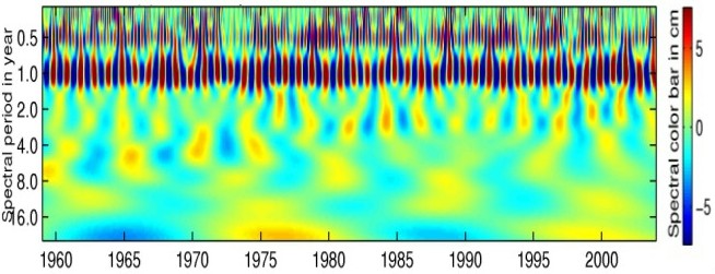
Selected projects on detection of sea level changeSea level change from tide gauge records and its relationship with El Niño events DING Xiao-li, ZHENG Da-wei, CHEN Yong-qi, W.T. WONG and W. LI Tide gauge records of this region including Hong Kong, Macau and some along the coast of Mainland China have been used to study seasonal, interannual and long-term changes in sea level (e.g., Figure 11), their relationship with phenomena such as El Niño, and their environmental impact. Vertical ground motion in the region is also being studied to as a n input to the study of long-term sea level change.
Figure 11. Wavelet time-frequency spectrum of sea level data in Hong Kong The impact of transient changes in mean sea level on local trend estimates from the PSMSL data H.M. NG and Baki IZ
Published values for global mean sea level trends determined from tide gauge
(TG) records are traditionally based on long data records. Although a large
number of globally distributed TG stations are needed to make reliable
inferences about global mean sea level trends, only a small number of stations
is used because several tide gauge records span short period of time and their
trend estimates are adversely affected by unmodeled periodic and transient mean
sea level variations. Automated change point algorithm is used to detect the
presence and the epochs of transient changes in mean sea level for all the 1862
stations in the Permanent Service Mean Sea Level (PSMSL) repository. We
subsequently model the transient changes with the unknown coefficients of
indicator variables in addition to the trend parameters and trigonometric
functions representing long periodic tidal effects and statistically significant
periodic fluctuations in the MSL. We show that the
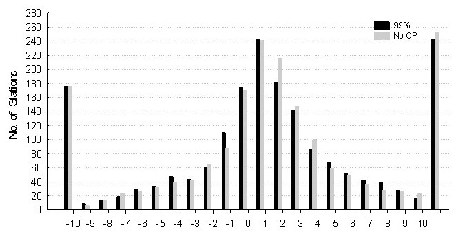
Figure 12. Binned Local Trend Estimates (mm/year) |