|
Crustal deformation monitoring with GPS and interferometric synthetic aperture radar (InSAR) technologies, including, measurement of land subsidence, and ground settlement, the deformation of large engineering structures, and slope stability monitoring for landslide prediction. The application of high resolution visible wavelength air and spaceborne sensors for landslide inventory, and landslide hazard assessment. Selected recent publicationsNichol, J.E. and Wong, M.S. (2005). Satellite remote sensing for detailed landslide inventories using change detection and image fusion. International Journal of Remote Sensing, 26(9), 1913-1926. Nichol, J.E. and Wong, M.S. (2005). Detection and interpretation of landslides using satellite images. Land Degradation and Development, 16:243-255. Ding, X.L., Liu, G.X., Li, Z.W., Li, Z.L. and Chen, Y.Q. (2004) Ground Settlement Monitoring in Hong Kong with Satellite SAR Interferometry, Photogrammetric Engineering and Remote Sensing, 70(10):1151-1156. Li, Z.L., Zou, W.B., Ding, X.L., Chen, Y.Q. and Liu, G.X., (2004) A quantitative measure for the quality of InSAR interferograms based on phase differences. Photogrammetric Engineering and Remote Sensing, 70(10):1131-1137. Liu, G.X., Ding, X.L., Li, Z.L., Li, Z.W. and Chen, Y.Q. (2004) Pre- and Co-Seismic Ground Deformations of the 1999 Chi-Chi, Taiwan Earthquake, Measured with SAR Interferometry, Computers and Geosciences, 30:333-343. Liu, G.X., Ding, X.L., Chen, Y.Q., Li, Z.L. and Li, Z.W. (2003). The pre-and co-seismic ground displacements of the 1999 Chi-Chi earthquake from ERS-SAR interferometry. Chinese Journal of Geophysics, 45:165-174. Wu, J.C., Tang, H.W., Chen, Y.Q. and Li, Y.X. (2003) Inversion of GPS measurements for a layer of negative dislocation distribution in north China, Journal of Geophysical Research, 108(B10):2481, doi:10.1029/2002JB002171. Wu, J.C. and Chen, Y.Q. (2002). Improvement of the separability of a survey scheme for monitoring crustal deformation in the area of an active fault. Journal of Geodesy, 76:77-81. Recent research grants
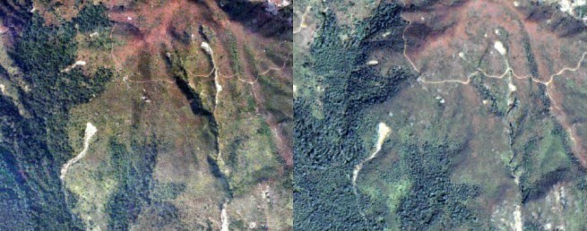
Selected projects on monitoring of earth movementsDetection and interpretation of landslides using satellite sensor images Janet NICHOL and WONG Man-sing Landslide monitoring which requires large areas to be surveyed at a detailed level has previously been unsatisfactory due to its reliance on air photo interpretation. This study demonstrates the synergistic use of medium resolution, multitemporal SPOT XS, and fine resolution IKONOS images for landslide inventories using change detection and image fusion. The visual quality of images obtained from Pan-sharpening of IKONOS images is comparable to that obtainable from 1:10,000 scale air photos (Figure 1). A methodology combining the two levels of survey is proposed for regional scale landslide monitoring.
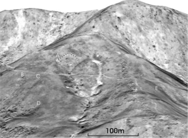
Figure 1. Digital orthophoto of 4.11.2002 (left) and IKONOS Pan-sharpened images of 28.1.2003, of landslides on Lantau Island, Hong Kong Investigation of stereo satellite images for landslide hazard assessment Janet NICHOL, Ahmed SHEKAR and WONG Man-sing Methods of landslide assessment using weighted overlays is based on the premise that areas where landslides have occurred in the past are more susceptible to future landslides. Due to vegetation growth it is often difficult to visually detect and inventory landslides older than 5 years. Therefore changes in ground elevation pre-and post-landslide can be used, and large areas can be inventoried using DEMs produced from stereo satellite images such as IKONOS. This research demonstrates that old landslide trails over 50 years old can be interpreted using a DEM from IKONOS stereo images (A-E on Figure 2).
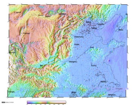
Figure 2. Panchromatic IKONOS image draped on IKONOS DEM. Landslide trail in centre is approximately of 15m wide and footpath crossing it is 1.5m wide. Crustal deformation monitoring by GPS CHEN Wu, Conrad TANG, CHEN Yong-qi and Li Zhi-lin The velocity field obtained by GPS surveying in North China during 1995 to 2001 is used for calculation of crustal deformation rates. The number of total GPS stations is about 450 in this area. A Delauney method is used for formulation of optimum triangles among observed GPS stations and the deformation rates in each triangle are calculated based on the velocities of the three vertex stations. By comparing the obtained deformation patterns with the Cenozoic tectonic movements in this area, they agree with each other. The obtained deformations are mainly distributed in the Huabai Basin and around a stable tectonic block, Ordos block (Figure 3). The maximum deformation rate obtained is 0.3ppm/a. The most significant maximum shear strain rates are found between Tianjing and Shijiazhuang, and they are properly related to two Quarternary active faults, Jinghai-Dacheng Fault and Cangdong Fault.
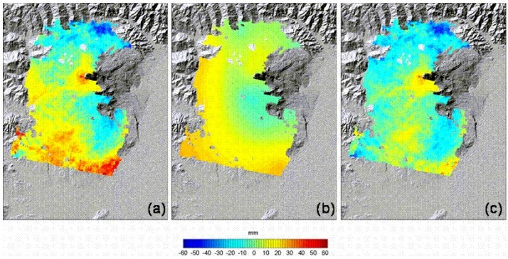
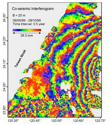
Figure 3. Deformation of the monitoring fields in north China Satellite radar remote sensing and its applications DING Xiao-li, CHEN Yong-qi, LI Zhi-lin, CHEN Wu, J.H. YIN, Z.W. LI and Peter DAMOAH-AFARI Research is being carried out to further develop interferometric synthetic aperture radar (InSAR) remote sensing technology, and apply it to the study of ground motions associated with land subsidence, earthquakes and landslides, as well as to generate large-scale digital terrain models (DEM). For example, Figures 4 and 5 below show respectively the application of an atmospheric model in InSAR measurement and the measured co-seismic ground motion associated with the major 1999 Taiwan Chi-Chi earthquake determined with InSAR. Unwrapped interferogram Modeled atmospheric fields Corrected interferogram
Figure 4. Modeling of atmospheric effects on InSAR measurements for better measurement accuracy of interferograms. (a) original unwrapped interferogram, (b) modeled atmospheric field, and (c) corrected interferogram.
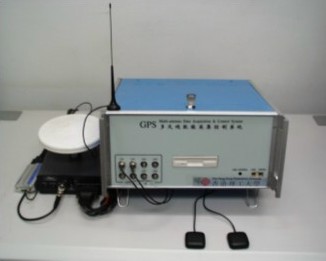
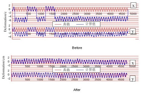
Figure 5. Interferometric fringes reflecting co-seismic ground deformation associated with the 1999 Taiwan Chi-Chi earthquake GPS and Its Applications for Structural Health Monitoring DING Xiao-li, CHEN Yong-qi, CHEN Wu, J.H. YIN, Y.L. XU, W.J. DAI, K.K. FAN, and P. ZHONG Research is being conducted to develop specialized technologies to apply GPS to monitoring the health conditions of structures such as bridges, tall buildings, slopes and dams. We have developed a patented multi-antenna GPS technology (Figure 6) that allows one GPS receiver to be used to monitor the motion of a series of points to substantially reduce the cost of GPS hardware. We have also been developing special data processing algorithms to enhance the accuracy and reliability of GPS (Figure 7).
Figure 6. A multi-antenna GPS developed by researchers in the group
Figure 7. Modeling GPS errors for more accurate GPS results |