|
In the last twenty years, we have witnessed great progress in satellite navigation technologies. Research and development in the group has mirrored this progress over many years, with emphasis on positioning precision. Selected recent publicationsChen, Wu and Hill, C. (2005). An Evaluation Procedure for Coordinate Transformation, J. of Eng. Surveying, 2. Chen, Wu, Hu, Cong-wei, Chen, Yong-qi, Ding, Xiao-li, Kwok and Simon Chi-wo (2003). GPS Rapid Static and Kinematic Positioning Based on GPS active network Geo_Spatial Information Science, 6(1):5-11. Li, Fei, Chen, Wu, and Yue, Jian-li (2003). On Solution and Application of GPS/Gravity Boundary Value Problem, Chinese Journal of Geophysics, 46(5):595-599. Li, Fei, Chen, Wu, and Yue, Jian-li (2003). Physical Geodesy with GPS, ACTA Geodaetica et Cartographica Sinica, 32(3):198-203. Chen, Wu, Hu, C.W., Ding, X.L., Chen, Y.Q. and Kwok, S. (2002). Critical Issues on GPS RTK Operation using Hong Kong GPS Active Network, Journal of Geospatial Engineering, 4(1):June 2002. Penna, N.T., Dodson, A.H. and Chen, Wu (2001). Assessment of EGNOS tropospheric correction model, Journal of Navigation, 54(1):37-55. Chen, Wu and Ochieng, W.Y. Galieo (2000). European Global Navigation Satellite System, Journal of Geospatial Engineering, 2(2):15-20. Moore, T, Dumville, Chen, Wu and Ashkenazi, V. (2000). Implications of the use of GNSS and WGS84 for Marine Navigation, Journal of Navigation, 54(1):37-55. Recent research grants
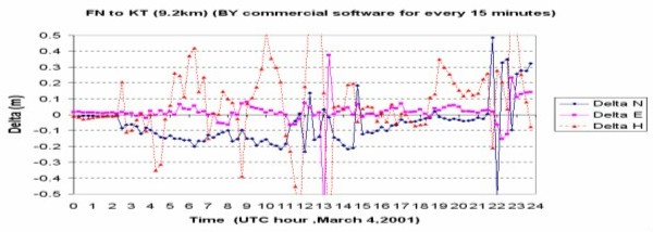
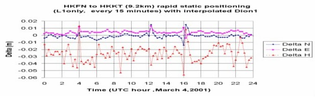
Selected projects on GPS and PositioningHong Kong Active Network CHEN Wu, CHEN Yong-qi and DING Xiao-li The Lands Department has established an active GPS network for surveying, navigation and environment studies. The department has been collaborated with the Lands Department in a number research areas, including atmospheric sensing and precise positioning with the active network. As Hong Kong is located near the equator, the ionospheric effects on GPS is the most difficult part to be modeled. That makes GPS kinematic positioning difficult in Hong Kong. Various methods have been developed to overcome this problem to improve the performance of kinematic positioning in Hong Kong.
Figure 21. Positioning errors with a commercial GPS processing software
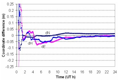
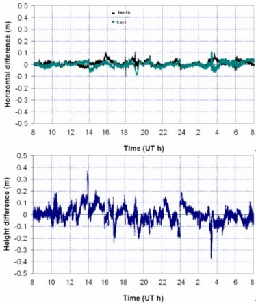
Figure 22. Positioning errors with LSGI approach for same data Precise Point Positioning (PPP) CHEN Wu, CHEN Yong-qi and DING Xiao-li The PPP method is a precise positioning method developed in recent years. With the precise IGS products on orbit and satellite clock errors, Centimeter positioning accuracy can be achieved with any reference stations around. The department has developed the PPP processing software for both static and kinematic positioning. New algorithm has been proposed to precisely estimate ambiguities in the kinematic mode.
Figure 23. Static Positioning with PPP method
Figure 24. Positioning errors with Kinematic PPP method |