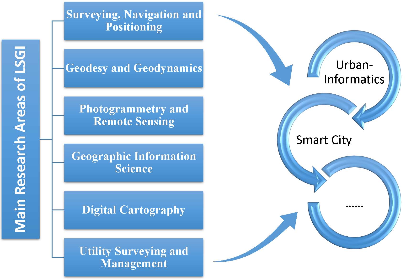


- Research Area
- Research Directions
- Research Outcomes
- Awards & Achievements
- Laboratories
- Cadastre Survey Laboratory
- Digital Cartography Laboratory
- Laboratory for Geographic Information Systems
- Geomatics Computing Laboratory
- Hydrographic Surveying Laboratory
- Navigation Laboratory
- Photogrammetry and Robotic Vision Laboratory
- Laboratory for Smart City and Spatial Big Data Analytics
- Survey Store and Instrumentation Laboratory
- Underground Utility Survey Laboratory
- Laboratory for Deformation and Geohazards Studies
- Remote Sensing Laboratory
- Research Centres
- Postgraduate Programmes
Strategic Research Area: Urban Informatics
Research Strengths
Listed below are research strengths currently focused by the Department:
Surveying, Navigation and Positioning 測量、導航和定位

Automation and enhancement of cadastral systems of Hong Kong; improvement of accuracy, reliability and efficiency in shallow water mapping using new technologies such as multi-beam echo sounders; development of GPS positioning technologies such as multi-antenna GPS; evaluation & modelling of GPS positioning errors; development of technologies for landslide and structure monitoring; multi-sensor and map matching techniques for navigation in high-rise urban areas; intelligent transport information systems; location-based computing and services; and fleet management.
Geodesy and Geodynamics 大地測量及地球動力學

Dynamical interaction between the solid Earth, oceans and atmosphere; El Nino; InSAR (Interferometric Synthetic Aperture Radar) for monitoring Earth surface deformation; precise determination of the geoid; space geodesy; sea-level change and impact assessment; applications of space geodetic techniques to study crustal deformation, atmospheric and environmental changes and the related natural hazards.
Photogrammetry and Remote Sensing 攝影測量及遙感
Applications of close-range photogrammetry and laser scanning in engineering and industry; fusion of satellite images; high-resolution image compression; environmental applications of remote sensing; remote sensing of the urban thermal environment; and two- and three-dimensional information extraction from high-resolution digital images.
Geographic Information Systems (GIS) 地理信息系統
Applications of GIS in transportation, and environment and facility management; spatial data structures, terrain modelling and computational geometry; data exchange and integration; dynamic marine GIS; multi-dimensional data models; scale theory; spatial databases; spatial data quality; spatio-temporal modelling; spatial decision support systems; and internet GIS.
Digital Cartography 數字化制圖
Automated map generalisation; cartographic visualisation; design of dynamic maps for vehicle navigation; multi-media presentation; multi-scale cartographic databases; and symbol design for tourist maps.
For general inquiries about the research programmes, please contact Prof. LI Zhi-lin, Chairman of Departmental Research Committee.