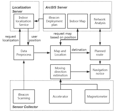
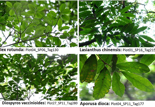
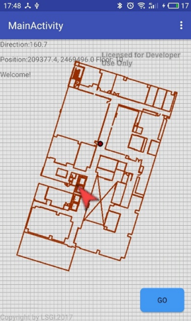
• +852 2766 4655
  • rs.lab@polyu.edu.hk
  • Home
  • Projects
    • Augmented Teaching and Learning Advancement System
    • An integrated knowledge-based Remote Sensing and GIS dynamic model for the urban thermal environment
    • A UV-based Remote Sensing Technology For Sulphur Dioxide Detection And Monitoring From Ship Emissions
    • A Practical Application of Integrated Micro-Environmental Monitoring System for Construction Sites
    • Assessing the Impact of Land Use Morphology on Air Pollution and Human Mobility for COVID-19 Incidence
    • Brownfield Classification
    • Coastal Water Quality Monitoring in Hong Kong
    • Characterization of Asian Dust Storms with Geostationary satellites MTSAT
    • Development of AI-based algorithms for classification of tree species and retrieval of tree parameters using handheld laser scanning
    • Development of Hyperspectral Library to Distinguish Urban Tree Species in Hong Kong
    • Environmental adaptability of settlement
    • Estimating Time-series of Anthropogenic Heat Flux at City Scale
    • Establishment of Hong Kong AERONET Station
    • Estimation of solar irradiation on the urban building rooftop in Hong Kong
    • iBeacon Positioning
    • Identification of Rock Outcrops Using Remote Sensing Techniques
    • Impact of The Super Typhoon Manghkut on The Secondary Forest of Hong Kong
    • Jockey Club Smart City Tree Management Project
    • Land Use and Land Cover Mapping of Pearl River Delta region and Hong Kong
    • LiDAR Technique Helps to Acquire Basic Tree Information
    • Machine learning-based estimation of solar potential on three-dimensional urban envelopes
    • MOOC Course: Introduction to Urban Geo-Informatics
    • Modelling Woody Vegetation in Sudano-Sahe-lina Zone of Nigeria Using Remote Sensing
    • Remote Sensing of Forest Succession in Hong Kong's Country Parks
    • Remote Sensing of Secondary Vegetation Succession in Hong Kong's Country Parks
    • Road Defect Detection Using Deep Learning Method
    • Solar Energy Supply in Cloud-prone Areas of Hong Kong
    • Tree Thermal Image
    • 70 Years of Forest Succession in the Degraded Tropical Landscape of Hong Kong
  • People
  • Contact Us

iBeacon Positioning

  • You are here:
  • Home
  • iBeacon Positioning
  • App Show

iBeacon Positioning

We utilize the iBeacon technology for indoor positioning and navigation based on different localization method.


  • Project Details

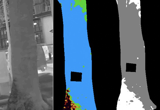
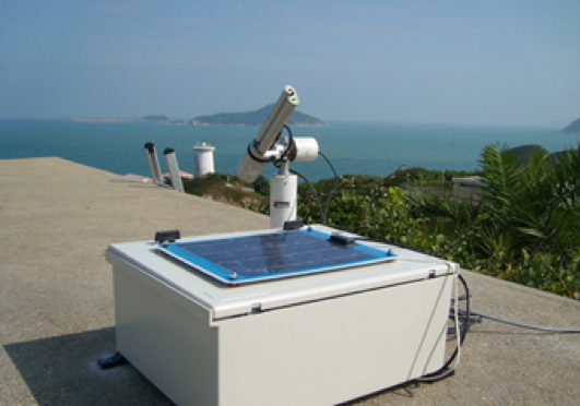
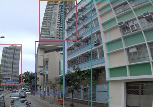
    Bluetooth Low Energy (BLE) technology provides opportunity for indoor positioning, which is a low-power and wireless technology built for the Internet of Things (IoT) developed by the Bluetooth Special Interest Group. The “iBeacon” specification was introduced by Apple Inc. and is widely used in mobile application development. The standard iBeacon tag transmits the general information through BLE. A BLE tag has an effective signal range up to tens of meters and it has a battery life that may last for several years. BLE technology has now been applied in Smart Homes, healthcare, security, entertainment and fitness areas. Modern smart devices (iOS 7+, Android 4.3+ and WP 10+) have the ability to receive BLE signals and run BLE applications. With the advancement of iBeacon, functions for the indoor environment such as LBS for disseminating advertisements in shopping malls and disseminating information in museums can be supported. BLE also realizes proximity-triggered interaction and also provides a solution for iLBS, since the iBeacon broadcasts Bluetooth signal continuously and smart devices can estimate the location by measuring the Received Signal Strength Indicator (RSSI) values. Recently, some mine haulage navigation applications have applied BLE technology.

Other Research Projects

  • Augmented Teaching and Learning Advancement System
     
    Jockey Club Smart City Tree Management Project
     
    Identification of Rock Outcrops Using Remote Sensing Techniques
    Remote Sensing of Secondary Vegetation Succession in Hong Kong's Country Parks
  • Estimating Time-series of Anthropogenic Heat Flux at City Scale
    Characterization of Asian Dust Storms with Geostationary Satellites MTSAT
    iBeacon Positioning
     
     
    Land Use and Land Cover Mapping of Pearl River Delta region and Hong Kong
  • MOOC course: Introduction to Urban Geo-Informatics
     
     
    A UV-based Remote Sensing Technology For Sulphur Dioxide Detection And Monitoring From Ship Emissions
    Coastal Water Quality Monitoring in Hong Kong
     
     
    A Practical Application of Integrated Micro-Environmental Monitoring System for Construction Sites
  • 70 Years of Forest Succession in the Degraded Tropical Landscape of Hong Kong
    Impact of The Super Typhoon Manghkut on The Secondary Forest of Hong Kong
    Development of Hyperspectral Library to Distinguish Urban Tree Species in Hong Kong
    Remote Sensing of Forest Succession in Hong Kong's Country Parks
  • Modelling Woody Vegetation in Sudano-Sahe-lina Zone of Nigeria Using Remote Sensing
    LiDAR Technique Helps to Acquire Basic Tree Information
     
    Road Defect Detection Using Deep Learning Method
     
    Tree Thermal Image
     
     
  • Solar Energy Supply in Cloud-prone Areas of Hong Kong
     
     
    Brownfield Classification
     
    Establishment of Hong Kong AERONET Station
     
    Environmental adaptability of settlement
     
  • Assessing the Impact of Land Use Morphology on Air Pollution and Human Mobility for COVID-19 Incidence
     
    Development of AI-based algorithms for classification of tree species and retrieval of tree parameters using handheld laser scanning

     Estimation of solar irradiation on the urban building rooftop in Hong Kong
     
     
    An integrated knowledge-based Remote Sensing and GIS dynamic model for the urban thermal environment
     
  • Machine learning-based estimation of solar potential on three-dimensional urban envelopes
  • Prev
  • Next

Copyright © 2018 - 2022.Remote Sensing Laboratory, The Hong Kong Polytechnic University. All rights reserved.

  •