• +852 2766 4655
  • rs.lab@polyu.edu.hk
  • Home
  • Projects
    • Augmented Teaching and Learning Advancement System
    • An integrated knowledge-based Remote Sensing and GIS dynamic model for the urban thermal environment
    • A UV-based Remote Sensing Technology For Sulphur Dioxide Detection And Monitoring From Ship Emissions
    • A Practical Application of Integrated Micro-Environmental Monitoring System for Construction Sites
    • Assessing the Impact of Land Use Morphology on Air Pollution and Human Mobility for COVID-19 Incidence
    • Brownfield Classification
    • Coastal Water Quality Monitoring in Hong Kong
    • Characterization of Asian Dust Storms with Geostationary satellites MTSAT
    • Development of AI-based algorithms for classification of tree species and retrieval of tree parameters using handheld laser scanning
    • Development of Hyperspectral Library to Distinguish Urban Tree Species in Hong Kong
    • Environmental adaptability of settlement
    • Estimating Time-series of Anthropogenic Heat Flux at City Scale
    • Establishment of Hong Kong AERONET Station
    • Estimation of solar irradiation on the urban building rooftop in Hong Kong
    • iBeacon Positioning
    • Identification of Rock Outcrops Using Remote Sensing Techniques
    • Impact of The Super Typhoon Manghkut on The Secondary Forest of Hong Kong
    • Jockey Club Smart City Tree Management Project
    • Land Use and Land Cover Mapping of Pearl River Delta region and Hong Kong
    • LiDAR Technique Helps to Acquire Basic Tree Information
    • Machine learning-based estimation of solar potential on three-dimensional urban envelopes
    • MOOC Course: Introduction to Urban Geo-Informatics
    • Modelling Woody Vegetation in Sudano-Sahe-lina Zone of Nigeria Using Remote Sensing
    • Remote Sensing of Forest Succession in Hong Kong's Country Parks
    • Remote Sensing of Secondary Vegetation Succession in Hong Kong's Country Parks
    • Road Defect Detection Using Deep Learning Method
    • Solar Energy Supply in Cloud-prone Areas of Hong Kong
    • Tree Thermal Image
    • 70 Years of Forest Succession in the Degraded Tropical Landscape of Hong Kong
  • People
  • Contact Us

Identification of Rock Outcrops Using Remote Sensing Techniques

  • You are here:
  • Home
  • IROURST
  • Rock outcrops samples near Shek O Road

  • Rock outcrops sample in Fei Ngo Shan

  • Classification result of High West, Hong Kong Island with year 2015 DOP

  • Probability map of rock outcrops of High West, Hong Kong Island with year 2015 DOP

  • Rock outcrop map of Hong Kong territory

  • Project Details

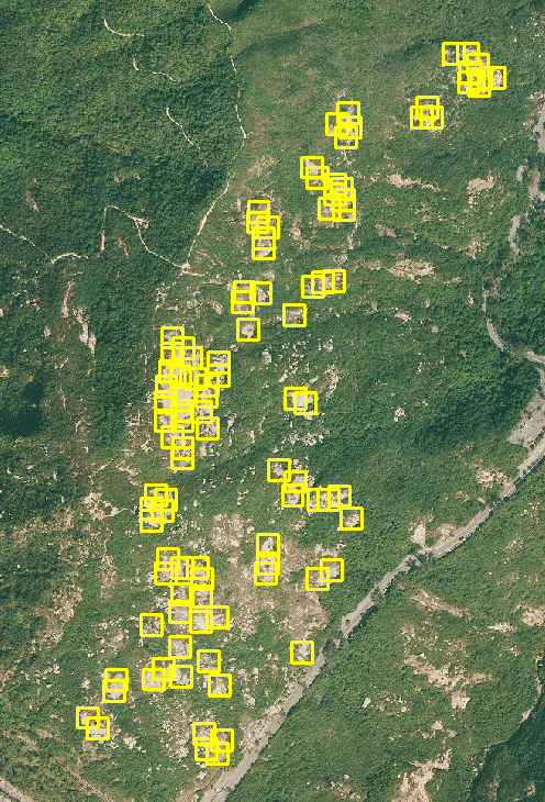
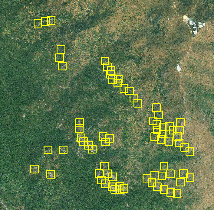
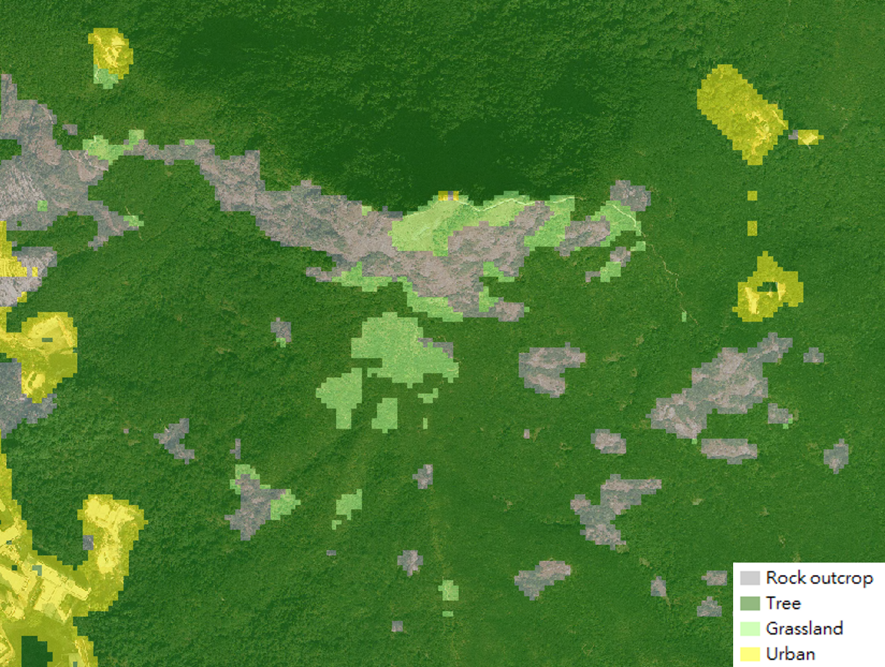
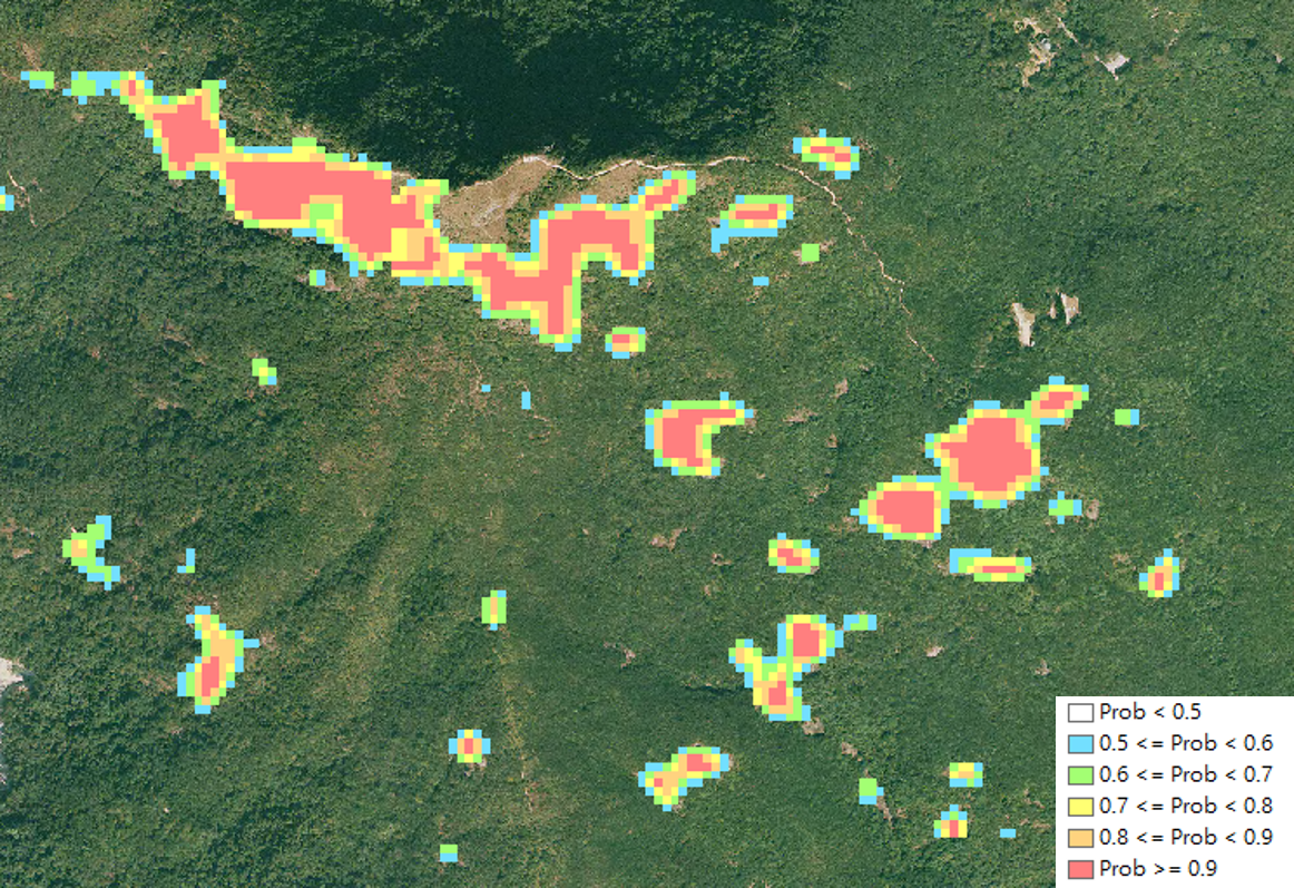
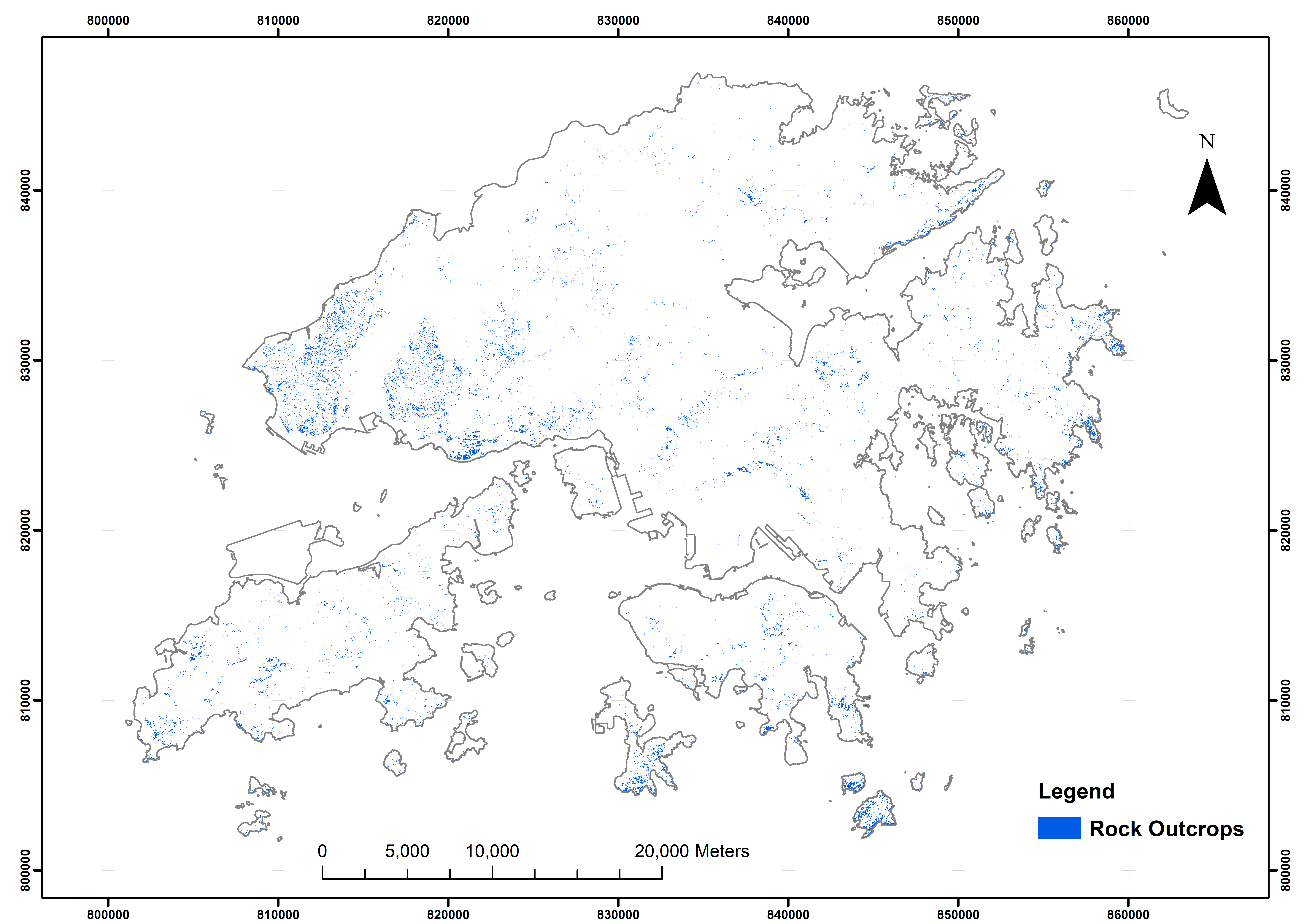
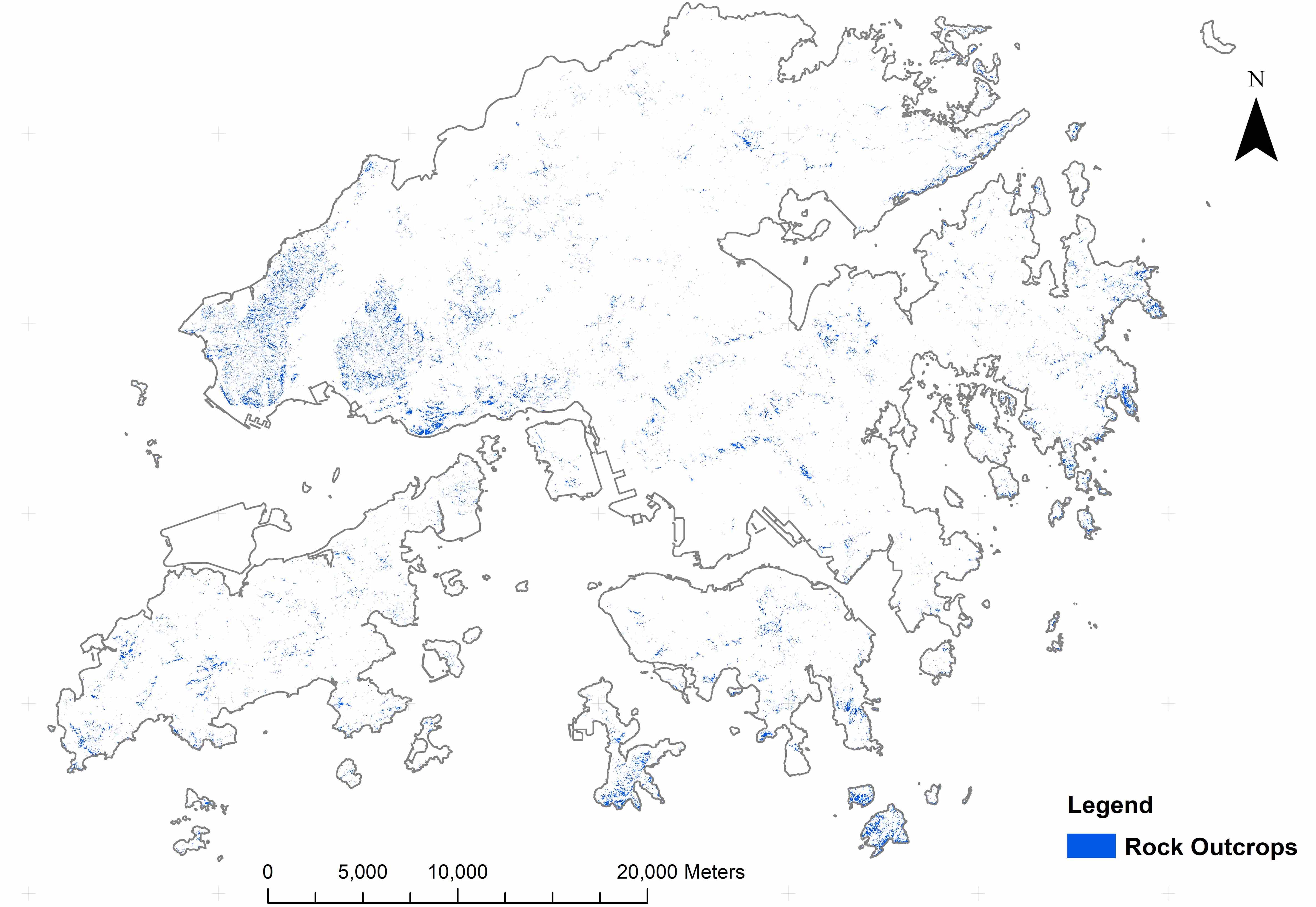
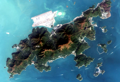
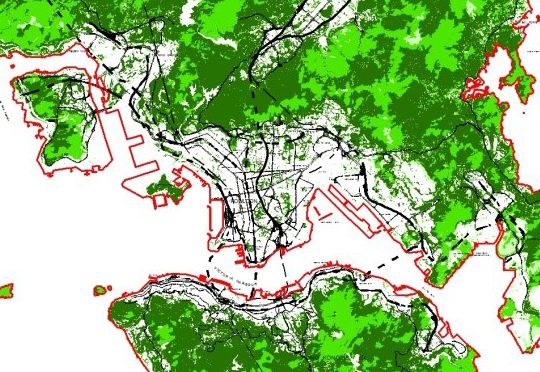
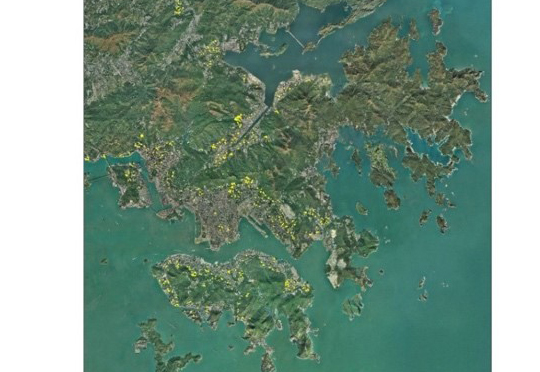
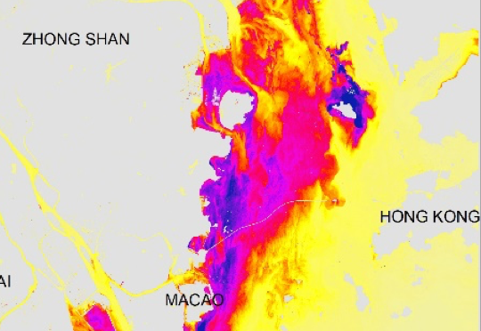
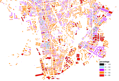
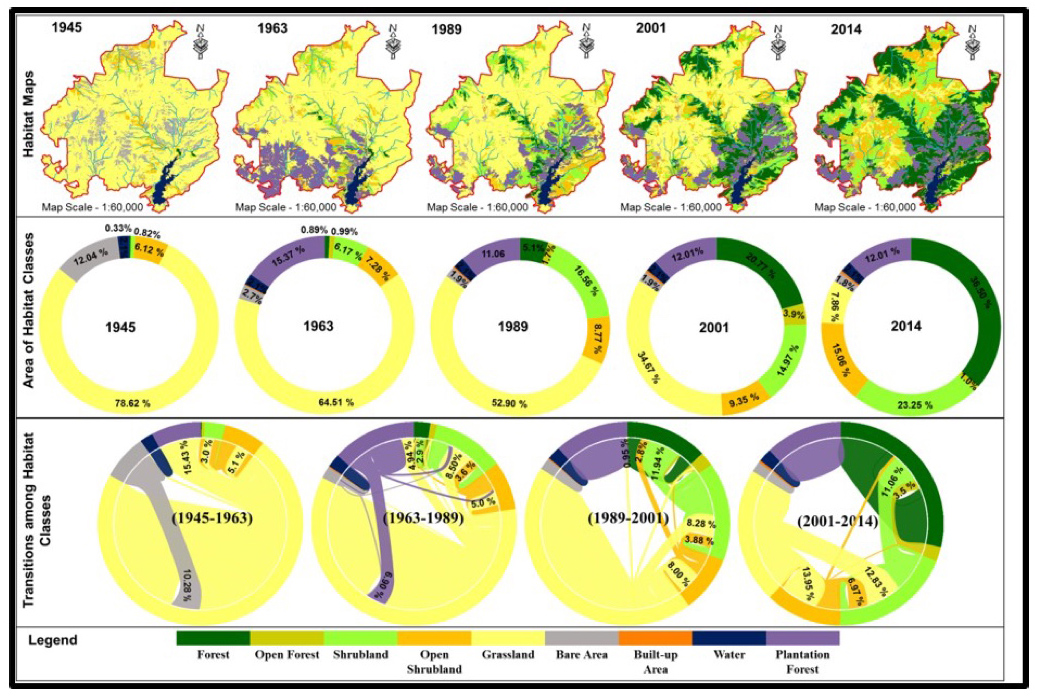
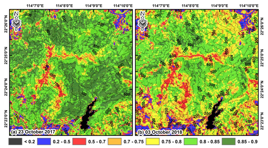
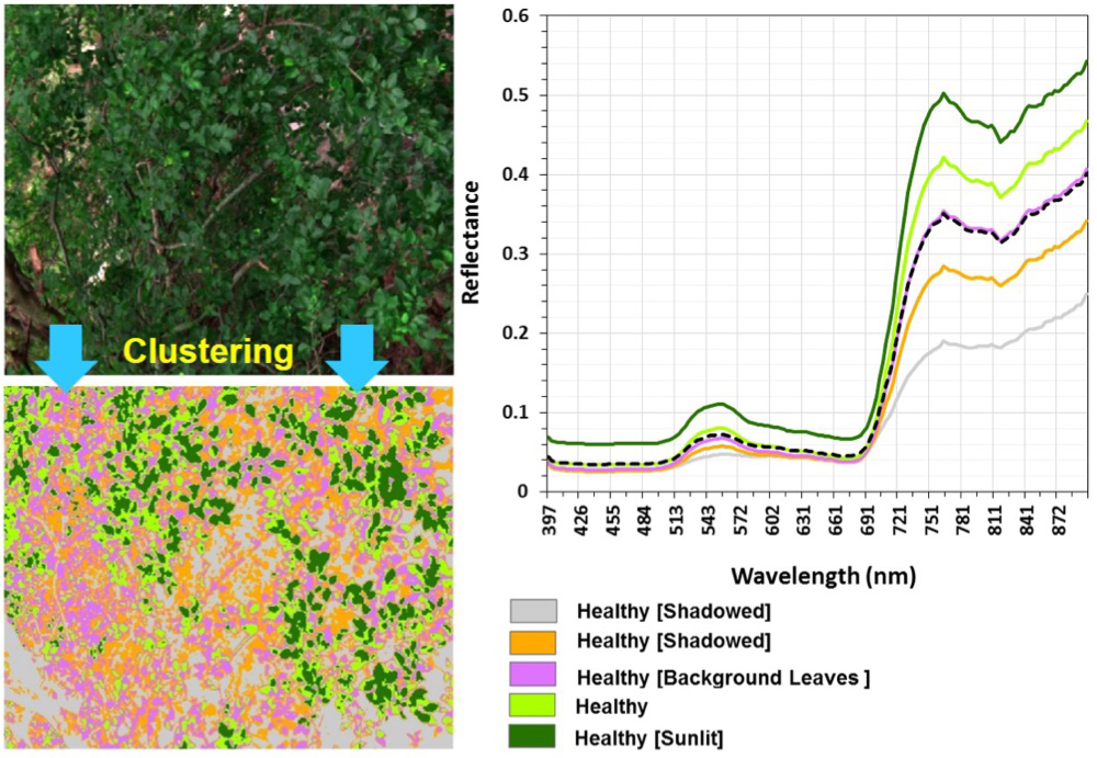
    To map the extents of rock outcrops in Hong Kong, a methodology of combining Convolutional Neural Network (CNN) which is a deep learning approach and remote sensing technique was developed in this study. Convolutional Neural Network was trained and applied to the digital orthophotos with a high resolution of 0.2m to generate a primary probabilistic map of rock outcrops. The map was further improved by remote sensing technique on SPOT image and geospatial technology of LiDAR data. The proposed methodology considered the spatial pattern of images from CNN, the spectral signature from SPOT image as well as spatial data from LiDAR provide comprehensive analysis on the attributes of rock outcrops.

    The rock outcrops were mapped in the natural terrain throughout the whole Hong Kong territories. The results from the proposed methodology were compared with the rock outcrops area mapped by engineering geologists using Aerial Photo Interpretation on the same sets of orthophotos for validation at three study areas, viz. Tin Wan and Mount High West on Hong Kong Island, and Castle Peak in the New Territories. Validation results show that a very high accuracy of over 94% with Kappa coefficient over 0.7 was achieved in natural terrain and moderately-high accuracy of 87% with Kappa coefficient of 0.64 was obtained in the badland area.

  • Acknowledgement

    This consultancy project (“Services for Identification of Rock Outcrops Using Remote Sensing Techniques”) is funded by Civil Engineering and Development Department.

Identification of Rock Outcrops Using Remote Sensing Techniques

This study proposed an innovative methodology by combining the deep learning technique of Convolutional Neural Network and remote sensing techniques to leverage the balance between spatial resolution and spectral resolution for mapping rock outcrops. A rock outcrops map of the entire Hong Kong territories is produced from this study.


Other Research Projects

  • Augmented Teaching and Learning Advancement System
     
    Jockey Club Smart City Tree Management Project
     
    Identification of Rock Outcrops Using Remote Sensing Techniques
    Remote Sensing of Secondary Vegetation Succession in Hong Kong's Country Parks
  • Estimating Time-series of Anthropogenic Heat Flux at City Scale
    Characterization of Asian Dust Storms with Geostationary Satellites MTSAT
    iBeacon Positioning
     
     
    Land Use and Land Cover Mapping of Pearl River Delta region and Hong Kong
  • MOOC course: Introduction to Urban Geo-Informatics
     
     
    A UV-based Remote Sensing Technology For Sulphur Dioxide Detection And Monitoring From Ship Emissions
    Coastal Water Quality Monitoring in Hong Kong
     
     
    A Practical Application of Integrated Micro-Environmental Monitoring System for Construction Sites
  • 70 Years of Forest Succession in the Degraded Tropical Landscape of Hong Kong
    Impact of The Super Typhoon Manghkut on The Secondary Forest of Hong Kong
    Development of Hyperspectral Library to Distinguish Urban Tree Species in Hong Kong
    Remote Sensing of Forest Succession in Hong Kong's Country Parks
  • Modelling Woody Vegetation in Sudano-Sahe-lina Zone of Nigeria Using Remote Sensing
    LiDAR Technique Helps to Acquire Basic Tree Information
     
    Road Defect Detection Using Deep Learning Method
     
    Tree Thermal Image
     
     
  • Solar Energy Supply in Cloud-prone Areas of Hong Kong
     
     
    Brownfield Classification
     
    Establishment of Hong Kong AERONET Station
     
    Environmental adaptability of settlement
     
  • Assessing the Impact of Land Use Morphology on Air Pollution and Human Mobility for COVID-19 Incidence
     
    Development of AI-based algorithms for classification of tree species and retrieval of tree parameters using handheld laser scanning

     Estimation of solar irradiation on the urban building rooftop in Hong Kong
     
     
    An integrated knowledge-based Remote Sensing and GIS dynamic model for the urban thermal environment
     
  • Machine learning-based estimation of solar potential on three-dimensional urban envelopes
  • Prev
  • Next

Copyright © 2018 - 2022.Remote Sensing Laboratory, The Hong Kong Polytechnic University. All rights reserved.

  •