|
Project Overview |
In October 2007, China
successfully launched its first lunar orbiter Chang'E-1 (CE-1). In
June 2009, NASA also launched the Lunar Reconnaissance Orbiter (LRO).
The Chinese CE-2 will also be launched in October 2010. Among the
science payload instruments on-board both the CE-1, CE-2 and LRO are
orbiter cameras and laser altimeters with different configurations
that collect data at various levels of resolution. This provides a
chance to use all the available data from multi-sensors and
multi-missions for precision lunar topographic mapping which cannot
be achieved when only using the data from a single sensor or single
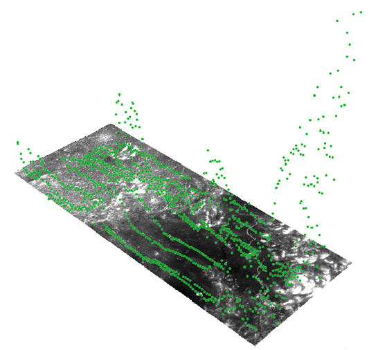
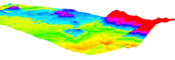
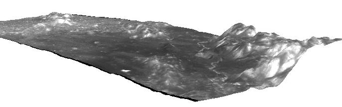
mission. This project plans to integrate the orbiter imagery with
laser altimeter data obtained from the CE-1, CE-2 and LRO missions
to develop high-precision topographic models to support future lunar
landed missions.
Most of the previous related
research is to process orbiter imagery and laser altimeter data
separately then do a comparison. This proposed research is an
endeavor to integrate the imagery and laser altimeter
data in order to reduce their inconsistencies and produce better
mapping results. This proposed project will contribute to the
advancement of the science and technology of planetary mapping. The
data integration capability enables cross-sensor and
cross-mission data correlation that will be very valuable for
various scientific investigations in lunar exploration missions and
beyond. This project will also enhance the contributions of Hong
Kong scientists to support the Chinese space exploration program.
|
|
Research Team |
Principal Investigator:
Dr.
Bo Wu, Department of Land Surveying & Geo-Informatics, The Hong
Kong Polytechnic University
Research Staff:
Jian Guo, Ph.D Student
Collaborators:
Dr. Ron Li, Professor, Director,
Mapping & GIS
Laboratory; The Ohio State
University
Dr. Kaichang Di, Professor,
Director, Planetary Mapping and Navigation Laboratory, Chinese
Academy of Sciences
|
|
Publications |
-
Bo Wu,
Fei Li, Lei Ye, Si Qiao, Jun Huang, Xueying Wu, and He Zhang,
2014. Topographic Modeling and Analysis of the Landing Site of
Chang’E-3 on the Moon, Earth and Planetary Science Letters, 405(2014):
257-273, doi: 10.1016/j.epsl.2014.09.009.
-
B. Wu,
H. Hu, and J. Guo, 2014. Integration of Chang'E-2 Imagery and
LRO Laser Altimeter Data with a Combined Block Adjustment for
Precision Lunar Topographic Modeling, Earth and Planetary
Science Letters, 391 (2014): 1–15,
doi:10.1016/j.epsl.2014.01.023.
-
B. Wu,
J. Guo, H. Hu, Z. Li, and Y. Chen, 2013. Co-Registration of
Lunar Topographic Models Derived from Chang’E-1, SELENE, and LRO
Laser Altimeter Data Based on a Novel Surface Matching Method,
Earth and Planetary Science Letters, 364 (2013): 68-84,
doi:10.1016/j.epsl.2012.12.024.
-
B. Wu,
H. Li, and Y. Gao, 2013. Investigation and Remediation of False
Topographic Perception Phenomena Observed on Chang'E-1 Lunar
Imagery, Planetary and Space Science, 75(2013): 158-166,
doi:10.1016/j.pss.2012.10.018.
-
J. Guo
and B. Wu, 2012. Comparison of Lunar Topographic Models Derived
from Multiple Sources Based on Least Squares Matching.
International Archives of the Photogrammetry, Remote Sensing and
Spatial Information Sciences, vol. XXXIX-B4, pp. 313-319.
-
B. Wu, J. Guo, Y. Zhang, B. King, Z. Li, and Y. Chen, 2011.
Integration of Chang'E-1 Imagery and Laser Altimeter Data for
Precision Lunar Topographic Modeling, IEEE Transactions on
Geoscience and Remote Sensing, 49(12): 4889 - 4903.
|