
Linear Spectral Unmixing Mapping Over Kowloon Peninsula |
This study evaluates the techniques of linear spectral unmixing (LSU), comparing high- and medium-resolution images for their ability to obtain separate estimates of tree and grassy surfaces in urban areas. It demonstrates that, unlike on medium-resolution images, tree and grassy surfaces each constitute distinct endmembers on high-resolution images. This is because at high resolution, shadows in the urban scene approximate pixel size and therefore can be separately masked, thus avoiding the spectral similarities between shadow and tree canopies on the one hand, and low albedo surfaces on the other. In this study, the ability to mask shadow on IKONOS VHR images removes these spectral overlaps. Spatial autocorrelation, applied to find the characteristic scale lengths of vegetated patches in the study area, demonstrated that at the 4m spatial resolution of IKONOS almost two thirds of pixels would be mixed, and at the 20 m resolution of SPOT all pixels would be mixed. Accuracies of the tree and grass fractions were found to be very high in the case of IKONOS, with 87% confidence that both the grass and tree fractions within each pixel were within 10% of the actual amount. The somewhat lower accuracy for SPOT supports previous studies based on medium-resolution sensors, which have noted that trees do not constitute an endmember. More details can be referred to:
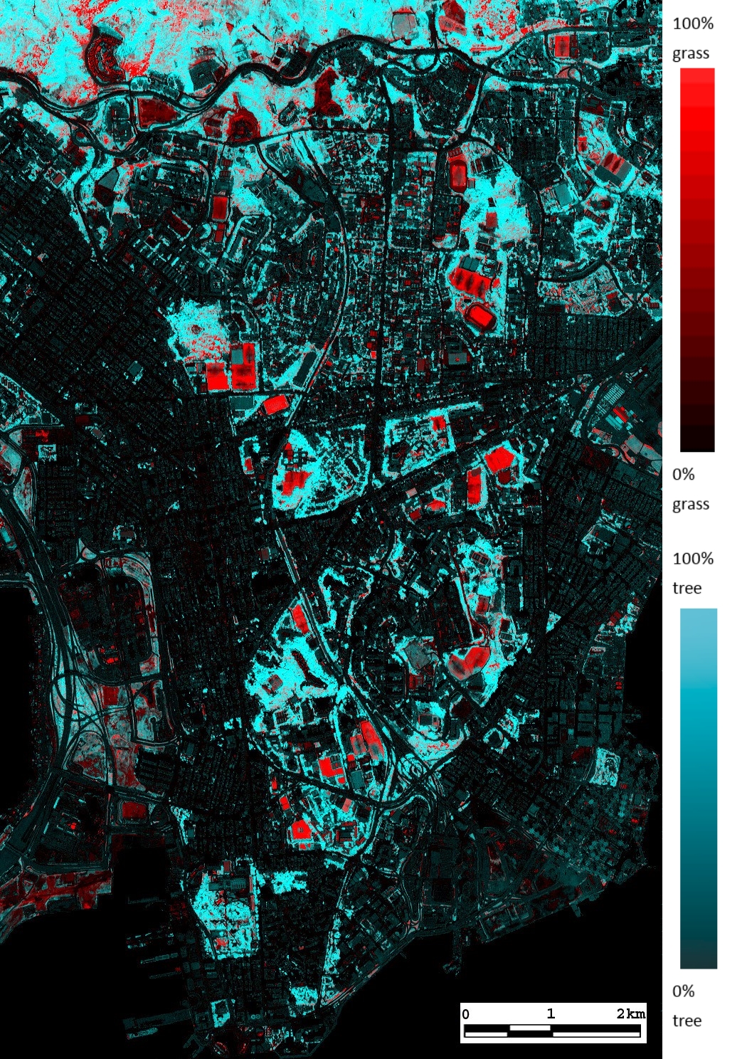 |
Grass and Tree Fraction image from IKONOS. Grass is displayed as Red color. Tree is represented by Blue and Green colors. |
The fragmentation, isolation and sparseness of vegetation in urban areas gives small patches of vegetation enhanced ecological value as habitat islands, compared with rural areas. Habitats as small as an individual tree may provide important landscape linkages across a densely urbanized city. Thus there is a need for micro-scale inventories of whole cities, which should incorporate not just biomass, but also vegetation of different life form, to support different habitat structural requirements. A combination of fine resolution multispectral satellite images from IKONOS, with the image processing technique of Linear Spectral Unmixing (LSU) permits the identification of different types of urban vegetation at sub-pixel level. Any fractional amount of grass and/or trees respectively within each 4 m IKONOS pixel can be identified.
To evaluate such fine scale inventory, least cost path (LCP) analysis was performed using pixel fractions representing
micro-scale tree habitats. This study adopts an innovative approach by allocating variable weightings to the vegetation
fraction amounts within each pixel, rather than to whole pixels. The result is a fuzzy friction surface, which constitutes
a very high-resolution database for input to fuzzy querying and decision-making. The friction values represent species’
preferences or tolerance levels, and may be varied according to the fraction amounts within a pixel. Automated mapping of
least cost pathways over different friction surfaces produced different routes across the study area, the densely urbanized
Kowloon Peninsula in Hong Kong. Comparison of the results with field data of bird sightings indicates the need for high
detail in urban ecological analysis. More details can be referred to:
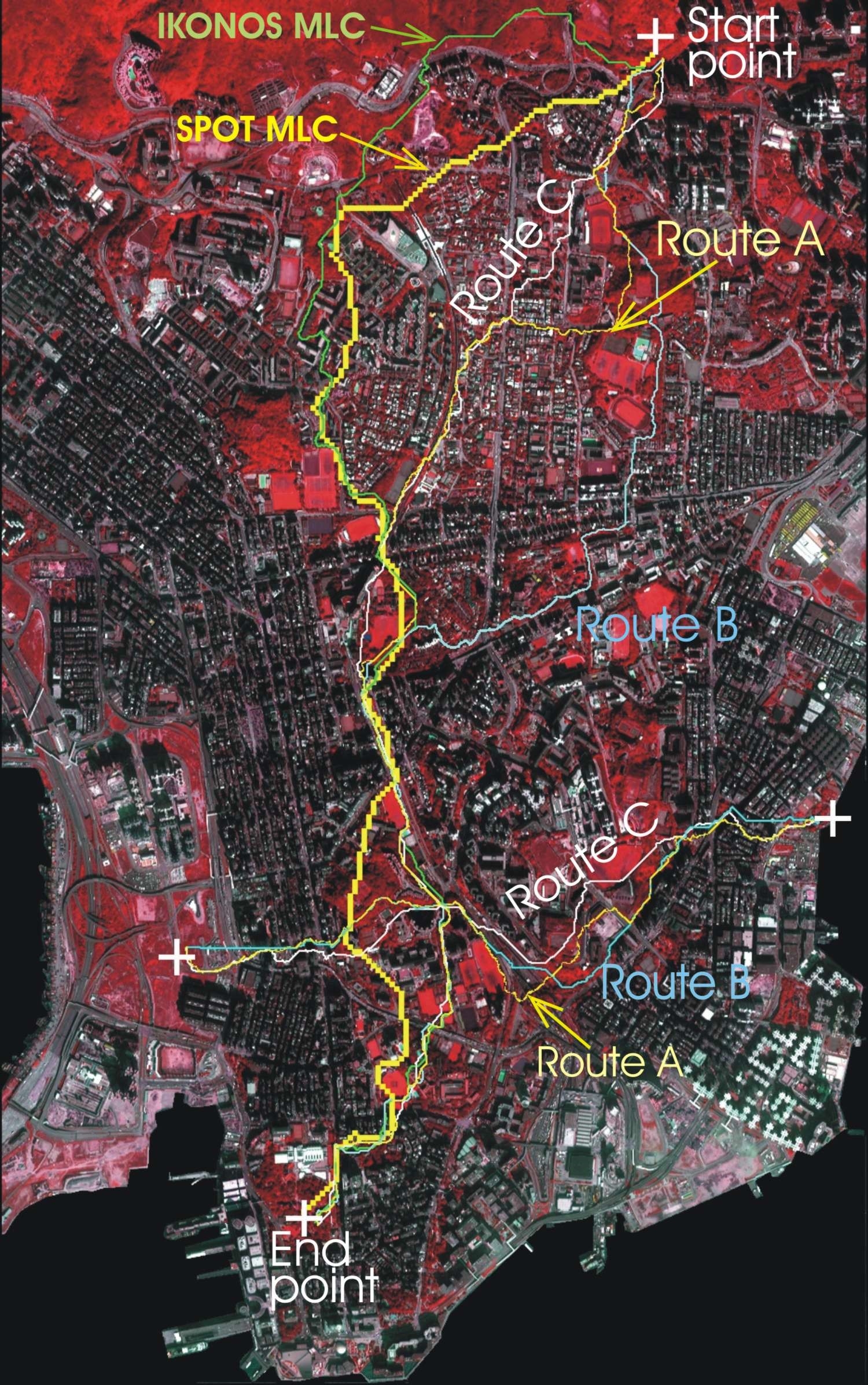 |
IKONOS MLC - Whole pixel classifier for IKONOS at 4m SPOT MLC - Whole pixel classifier for SPOT at 20m Route A - Route with only thick and dense tree covers Route B - Route with thick to medium tree covers, parks and large tree patches Route C - Route with any amount of tree covers but no limitations on tree patch size |
Nichol J. E. and Wong M. S. (2007), Remote sensing of urban vegetation life form by spectral mixture analysis of high-resolution IKONOS satellite images, International Journal of Remote Sensing, 28(5), 985-1000.