
Cloud Detection |
The MTSAT satellite images store both the latitude and longitude information of each pixel. And the satellite orbital information is known. The instantaneous satellite viewing geometry can then be estimated.
Radiances at the top of the atmosphere (TOA) measured by satellite sensors are influenced by both atmosphere and land surface properties. Radiance measured by sensors mainly comprised of two parts, the atmospheric scattering and surface reflected solar radiance. In this study, atmospheric parameters retrieved by different algorithms from satellites together with other climatology and ancillary data were used as inputs in Radiative Transfer Model to simulate the cloud free top of atmosphere apparent reflectance for MTSAT visible wavelength. The simulation was conducted using the "Second Simulation of the Satellite Signal in the Solar Spectrum" (6S) radiative transfer model which wa developed by Vermote et al. (1997).
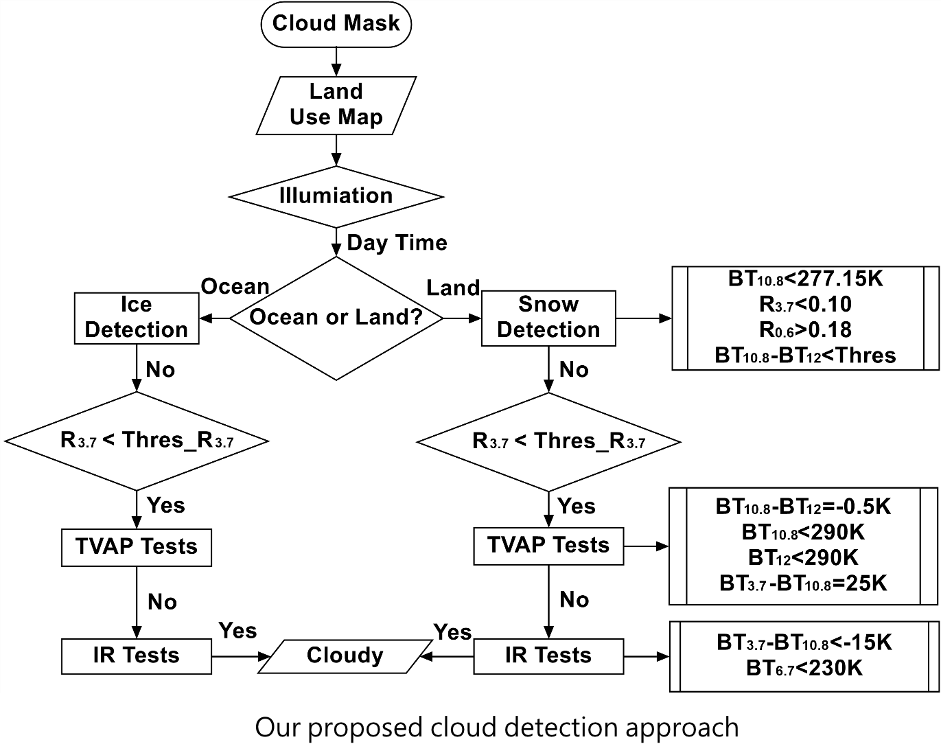
In the same solar satellite viewing geometry, the reflectances of clouds are often larger than the reflectance of land or ocean. And cloud temperatures observed by satellite are often cooler than the underlying surface temperature. Thus, these cloud properties could be applied in the threshold testing for cloud detection.
Validation has been conducted through the direct comparison with MODIS cloud mask products MOD06. The 36 channel MODIS instrument provides a high spatial (1 km) and high spectral resolution from the shortwave visible to the longwave infrared spectrum. The comparison was conducted using pixel by pixel method. A temporal matching criterion is +/- 5 minutes between the MODIS and MTSAT measurement. The study region covers the Hong Kong territories, from 20° N to 24° N latitude and from 112° E to 116° E longitude. The lowest and highest success ratios of validation dataset are 0.84 and 0.97, respectively. The success ratio indicates the degree of consistence between the results of MTSAT and MOD06. The location with success ratio below average is mainly due to small thin clouds which cannot be identified from MTSAT images.
Vermote, E. F., Member, IEEE, Tanre, D., Deuz ´ e, J. L., Herman, M. and Morcrette, J., 1997. Second Simulation of the Satellite Signal in the Solar Spectrum, 6S: An Overview. IEEE Transactions on Geoscience and Remote Sensing 35(3), 675.